There are weird landforms in the NE corner of Estonia which are called kriiva in Estonia. Most of them look like dunes and they are composed of fine sand but there are some difficulties.
First researchers almost 100 years ago thought that these landforms are marginal moraines because their NE-SW orientation match the orientation of the continental glaciers margin there some 12,000 years ago. However, we see no sign of deformations which should be there if we assume that these landforms are the result of a bulldozing work of an advancing glacier. This hypothesis is largely rejected now.
What is the problem then? First of all, there seems to be at least two morphologically different types of kriivas. First ones are straight and the other ones are curved. I visited several of these landforms about a month ago with some fellow geologists.
We first visited one of the straight kriivas and thought: what a heck, this is like a railway dam running straight through the forest. I never thought that a sand dune might look like this. Both sides of the landform had similar steepness. We made some excavations to look for a cross bedding but found only very subtle hints of it. The layers were mostly parallel and composed of fine well sorted sand. My belief in the dune hypothesis was quickly waning although I couldn’t figure it out what else it might be. All right, let’s assume we had a marginal crack in the glacier where the sediments were accumulating. But the sediments are too well sorted. Glaciers carry all kinds of material from clay particles to large boulders but there were only fine sand.
Then came the curved ones which were different. They are morphologically clearly resembling dunes (one side steeper than the other) and there were some cross bedding in the upper parts of the dune. However, interestingly the lower part of the dune had parallel alternating layers of silt and sand which is a characteristic to ice lake sediments (somewhat similar to varved clay sequences) and definitely not to dunes.
Well, our preliminary conclusion was that maybe these dunes were not dunes at the beginning. Maybe they were indeed some sort of “lake” sediments formed in a narrow crack? When the glacier retreated, some of these straight sandwalls were reworked and became curved dunes and some for some reason remained intact? I really don’t know the answer but if any one of you have experienced something similar, I and one of my friends who is writing his bachelor thesis on these dunes would appreciate it.
Google Maps is not very competent in this region but here is a link to that area.
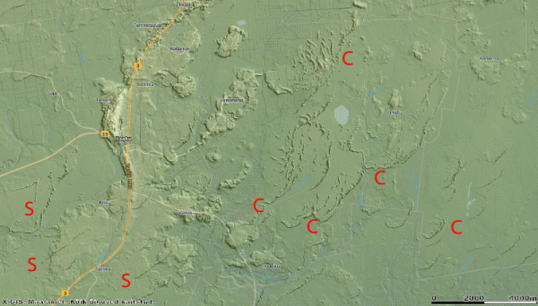
Here is an overview of the area taken from the Estonian LIDAR relief map. S — straight dune, C — curved dune. This map is a courtesy of Estonian land Board.
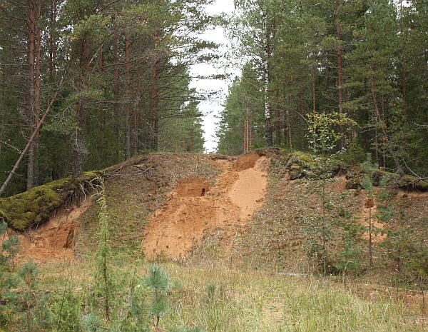
There are many small and mostly abandoned sand quarries which made our job a lot easier. This is the cross section of a straight kriiva. It almost seems to be like a manmade landform.
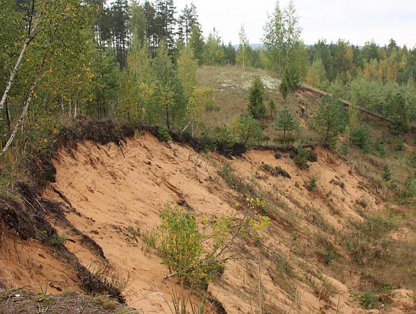
Curved kriiva. These dunes are composed of many smaller dunes that are sitting one on top of the other.
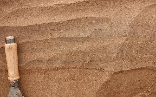
Alternating layers of silt (darker) and sand (lighter) in the lower part of one of the curved dunes.
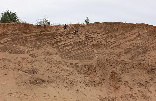
Here we see clearly that the layers (slip side of the dune) are inclined. I measured the maximum true dip which is 28 degrees. The dip of the same dunes windward side was approximately 8 degrees. These are quite characteristic numbers for a dune.
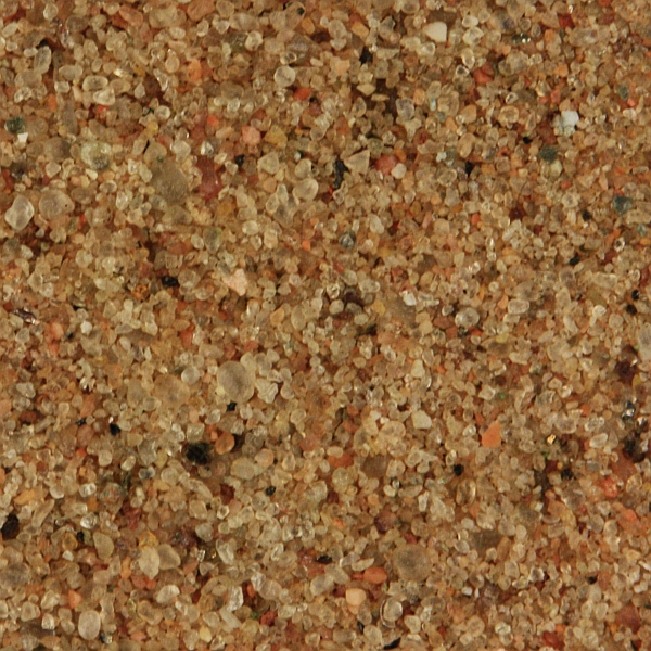
Here is an example of the material these dunes are made of. It is fine sand but surprisingly not too well sorted. Note how large are some quartz grains compared to the rest. Dune sands are generally very well sorted so it may be a sign that in this case the transport route of the grains have been very short. It is compositionally typical continental sand. Quartz and K-feldspar are the most important constituents. The width of the view is 5 mm.
Very interesting! How about this hypothesis: maybe the entire area was initially a dune field formed on a dry glacial lake bed (hence the varved sediments at the bottom). The curved kriiva in the SE part of the lidar image could be blown-out remains of original dunes (parabolic dunes? What is the prevailing wind direction in this part of Estonia? NW to SE?). Later, a glacier advanced from the NW and bulldozed some of the dunes, forming recessional moraines (middle part of the lidar image). Maybe the reason these moraines only contain well-sorted sand is because that’s all there was for the glacier to work with–no gravel, no clay, only sand. The straight kriiva in the SW part of the lidar image might be short eskers; again, they only contain sand because that is the only sediment size that was available. The horizontally bedded sand in the straight kriiva is consistent with esker deposits. Good idea? Bad idea?
You have a great blog–keep up the good work!
Howard, this is very good point that the glacier had nothing else to work with than sand. If the hypothesis I described above is correct in major parts then it had to be the case.
Prevailing wind at that time was NW.
There is actually one large esker running N-S (major positive landform on the left part of the image). The village of Iisaku is on top of it. This esker contains much coarser material than kriivas.
I didn’t mention that some kriivas contain lenses of coarse sand. Where is this sand coming from? Maybe from that esker, its hard to come up with other explanations.
I am a bit sceptical about the version that there were dune field before. Our current understanding is that these dunes formed when the glacier had been long gone. Kriivas really show no sign whatsoever that they have been somehow reworked by the glacier.
In Latvia and I assume the same applies to Estonia most of the surface sediments are deposited in glaciation – deglaciation related processes either as moraines or fluvioglacial sandy material or even clays deposited in ice-walled lakes. One way to form the structures you saw could be by meltwater streams flowing under the glacier. Then sediments can be relatively well sorted. If I would let my imagination run wildly, I would say that straight landforms are probably made by the streams which utilized existing fracture in the glacier but the curved ones where formed when the stream had to melt its way trough the ice. But as I said this is just a guess without having an experience working on glacier deposits.
Yes, there is a temptation to explain it that way. Unfortunately there is nothing in the field to suggest that this sand is deposited by the running water.